Boost Property Value with a Topographic Survey in Denver

Surveyor adjusting a leveling instrument on a property site—highlighting the importance of topographic survey for land development and value assessment.

If you own property in Denver, you likely know how valuable your land can be. One effective way to maximize its value is by getting a topographic survey. This type of survey helps you understand your property’s features and potential clearly, helping you avoid costly mistakes and make smarter decisions.

How a Topographic Survey Can Increase Your Property’s Value

1. Identify the Best Use of Your Property

A topographic survey clearly shows your land’s elevations, slopes, and physical features. With this information, you can:

  • Decide the ideal location for buildings or landscaping.
  • Plan expansions or subdivisions efficiently.
  • Maximize usable land space.

2. Improve Landscaping and Curb Appeal

Accurate terrain data helps create appealing and functional landscapes. This can:

  • Increase curb appeal.
  • Enhance property attractiveness to buyers or renters.
  • Raise your property’s market value.

3. Optimize Drainage and Flood Management

Denver’s varied climate can cause drainage issues. A professional survey helps you:

  • Identify potential flooding risks.
  • Plan drainage systems effectively.
  • Prevent future damage and expensive repairs.

Common Mistakes Property Owners Make (and How to Avoid Them)

1. Not Understanding Property Boundaries

Unclear boundaries can lead to disputes or costly corrections later. To avoid this:

  • Get clear boundary lines from your topographic survey.
  • Clearly mark boundaries before making improvements.

2. Ignoring Terrain Challenges

Uneven terrain can cause unexpected construction expenses. Prevent this by:

  • Reviewing terrain data carefully before building or landscaping.
  • Adjusting project plans based on your survey results.

3. Overlooking Environmental Restrictions

Environmental limitations, like protected areas, can halt development. Avoid this by:

  • Discussing environmental concerns with your surveyor.
  • Planning projects according to local regulations.

Practical Tips to Maximize Property Value

  • Always hire a licensed and experienced local surveyor.
  • Use your survey data to inform every decision, from design to construction.
  • Regularly update surveys, especially before major property changes.

FAQs

1. What exactly is a topographic survey?
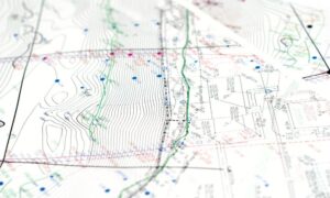
It’s a detailed map showing land elevations, slopes, and natural features, helping you plan development effectively.

2. Do I really need a topographic survey for my Denver property?
Yes, especially before construction, landscaping, or major property decisions. It prevents mistakes and maximizes land value.

3. How long does a topographic survey usually take in Denver?
Typically, a survey takes about 1-2 weeks, depending on your property size and complexity.

4. Can a topographic survey help with building permits?
Yes, accurate surveys are often required by Denver authorities to approve building permits and ensure compliance.

5. What’s the average cost for a topographic survey in Denver CO?
Costs vary based on property details, usually ranging from $600 to $3,000. Always ask for a quote from your surveyor first.
author avatar
Surveyor

More Posts

Aerial view of a flooded riverbank near urban properties showing why an ALTA survey is essential after extreme weather events.
alta survey
Surveyor

How an ALTA Survey Protects Property After Floods

Colorado’s rivers have a way of reminding us who’s really in charge. Just this week, record-breaking floods swept across the Western Slope, forcing hundreds to evacuate in La Plata and Archuleta counties. While Denver didn’t flood, the story still hits close to home. After all, we share the same watershed

Read More »
Land surveyor using a total station to measure and verify ground distances for an ALTA Title Survey.
alta survey
Surveyor

ALTA Title Survey: How to Apply the Combined Scale Factor

Getting an ALTA Title Survey right in Denver takes more than just measuring and mapping the land. Because Denver sits more than 5,000 feet above sea level, small errors in distance can cause big problems later. One of the most common mistakes happens when surveyors forget to adjust for the

Read More »
Drone surveying rugged valley with creek and NASA radar overlay showing flood and landslide risk detection
land surveying
Surveyor

NASA Radar & Drone Surveying: Smarter Flood, Landslide Risk

Technology is changing how we see the ground beneath our feet. Last Week, NASA released the first radar images from its new NISAR satellite. The results were impressive. This satellite can detect ground movements as small as a few millimeters, giving scientists a powerful way to monitor slopes, rivers, and

Read More »
Construction survey being performed by two surveyors with total station and plans on a roadway site
land surveyor
Surveyor

How a Construction Survey Helps Prevent Road Collapses

Late last month, Littleton city officials announced that South Broadway would close through spring 2026. The reason wasn’t a new development or a flashy project. Instead, it was to replace a failing culvert and build a safer walkway. Without this work, the road faced the real risk of collapse. This

Read More »
Aerial view of urban land with digital boundary lines representing boundary surveys for land development.
boundary surveying
Surveyor

Why Boundary Surveys Matter in Land Swaps and Growth

When people talk about city growth and new parks, they usually don’t think about land surveyors. But behind the scenes, boundary surveys play a huge role in shaping cities like Denver. Without them, big land deals—like the one involving the Park Hill Golf Course—would be a legal and logistical mess.

Read More »
Aerial view of land parcels in a growing neighborhood where developers need ALTA Land Title Surveys before construction
alta survey
Surveyor

Developers Rely on ALTA Land Title Surveys

Denver’s real estate market is booming. Developers are buying land fast, and with so many deals happening, ALTA Land Title Surveys have become very important. These surveys show developers exactly what they are buying, help avoid mistakes, and keep projects moving on time. In Denver, where property prices are climbing

Read More »