How To Find Your Property On FEMA’s Flood Insurance Rate Maps

What are FEMA flood maps?
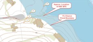
FEMA’s Flood Insurance Rate Maps (FIRMs) or just Flood Maps are provided after a flood risk assessment has been completed or updated for a community.  This study is known as a Flood Insurance Study.  The FIRM gives you the Base Flood Elevations (BFEs) and insurance risk zones in addition to floodplain boundaries.  The FIRM may also show a delineation of the regulatory floodway.

Once the “insurance risk zone”  (commonly referred to as the flood zone) is determined, actuarial rates, based on these risk zones, are then applied for newly constructed, substantially approved, and substantially damaged buildings.  FEMA uses these rates to determine the insurance rate you will pay for flood insurance

FEMA’s Digital Flood Maps

FEMA discontinued the production and distribution of paper flood maps in 2009 as part of its Digital Vision Initiative. This affected all the Flood Maps, boundary information, and study reports. However, clients can still view the products for free through their website or buy them in digital format.

To view these flood maps online, go to FEMA’s Map Service Center and key in your address (hi-lited area shown here) search for your home.  This will prompt you to then select the map that covers your area.  The Flood Maps are somewhat cumbersome to use online. It is best to go through the tutorial on the bottom right of the address search page for an easier and more effective use of the GIS map.
author avatar
Surveyor

More Posts

Aerial view of a flooded riverbank near urban properties showing why an ALTA survey is essential after extreme weather events.
alta survey
Surveyor

How an ALTA Survey Protects Property After Floods

Colorado’s rivers have a way of reminding us who’s really in charge. Just this week, record-breaking floods swept across the Western Slope, forcing hundreds to evacuate in La Plata and Archuleta counties. While Denver didn’t flood, the story still hits close to home. After all, we share the same watershed

Read More »
Land surveyor using a total station to measure and verify ground distances for an ALTA Title Survey.
alta survey
Surveyor

ALTA Title Survey: How to Apply the Combined Scale Factor

Getting an ALTA Title Survey right in Denver takes more than just measuring and mapping the land. Because Denver sits more than 5,000 feet above sea level, small errors in distance can cause big problems later. One of the most common mistakes happens when surveyors forget to adjust for the

Read More »
Drone surveying rugged valley with creek and NASA radar overlay showing flood and landslide risk detection
land surveying
Surveyor

NASA Radar & Drone Surveying: Smarter Flood, Landslide Risk

Technology is changing how we see the ground beneath our feet. Last Week, NASA released the first radar images from its new NISAR satellite. The results were impressive. This satellite can detect ground movements as small as a few millimeters, giving scientists a powerful way to monitor slopes, rivers, and

Read More »
Construction survey being performed by two surveyors with total station and plans on a roadway site
land surveyor
Surveyor

How a Construction Survey Helps Prevent Road Collapses

Late last month, Littleton city officials announced that South Broadway would close through spring 2026. The reason wasn’t a new development or a flashy project. Instead, it was to replace a failing culvert and build a safer walkway. Without this work, the road faced the real risk of collapse. This

Read More »
Aerial view of urban land with digital boundary lines representing boundary surveys for land development.
boundary surveying
Surveyor

Why Boundary Surveys Matter in Land Swaps and Growth

When people talk about city growth and new parks, they usually don’t think about land surveyors. But behind the scenes, boundary surveys play a huge role in shaping cities like Denver. Without them, big land deals—like the one involving the Park Hill Golf Course—would be a legal and logistical mess.

Read More »
Aerial view of land parcels in a growing neighborhood where developers need ALTA Land Title Surveys before construction
alta survey
Surveyor

Developers Rely on ALTA Land Title Surveys

Denver’s real estate market is booming. Developers are buying land fast, and with so many deals happening, ALTA Land Title Surveys have become very important. These surveys show developers exactly what they are buying, help avoid mistakes, and keep projects moving on time. In Denver, where property prices are climbing

Read More »